Newly developed artificial intelligence software promises to help growers to better keep on top of their vineyard operations. Project GAIA, which utilises satellite imagery, aims to provide critical data to enable producers to more effectively monitor soil moisture, assess fruit quality and monitor the performance of vines, among its other features.
Journalist Samuel Squire spoke to one of GAIA’s lead developers, Dr Sebastien Wong, and chief executive Andy Clarke, to learn more about the application’s industry potential.
Grapegrowers are being given the opportunity to utilise new artificial intelligence (AI) software to more effectively manage their operations.
Project GAIA (Geospatial Artificial Intelligence for Agriculture) was developed to aid viticulturists, vineyard managers and others gather critical information that can be used to monitor under-performing areas within their vineyard and assist in improving the overall health and productivity of their vines.
The ancient Greek goddess, after whom the project is named, was said to be the personification of the Earth. In a comparable way, the technology aims to be growers’ omnipresent ‘eye in the sky’, monitoring data patterns within the vineyard from above.
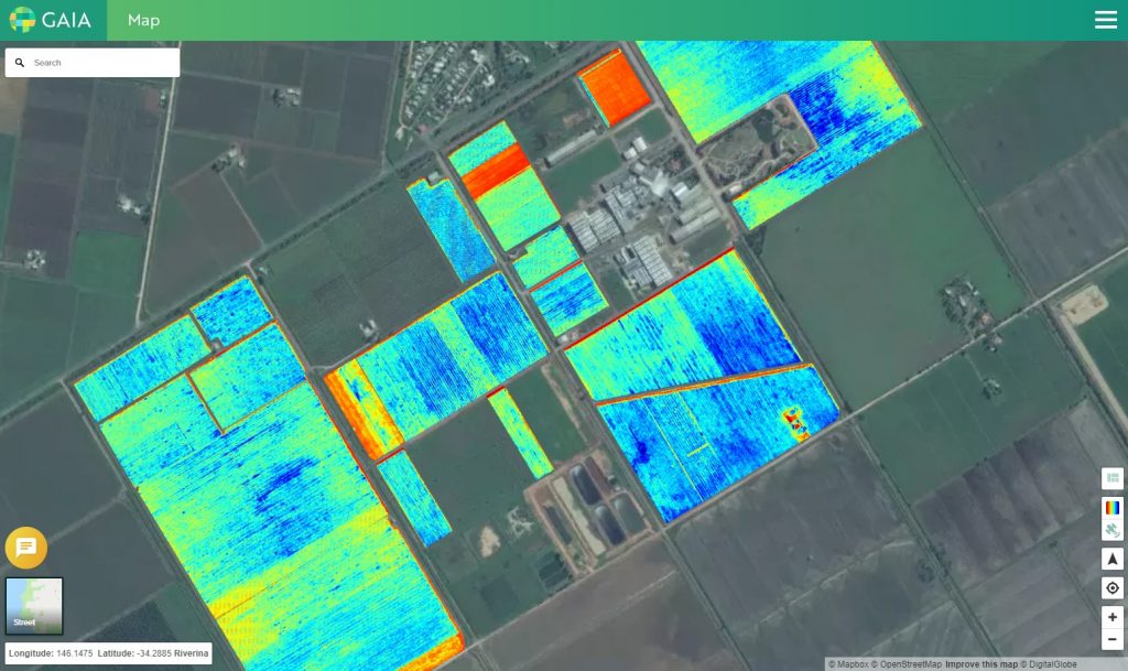
GAIA has digitally mapped more than 145,000 hectares of vineyards in Australia to date, in two nation-wide scans using the WorldView-3, WorldView-2 and GeoEye-1 satellites, releasing digital maps from the 2019 growing season.
An eye for detail
In its current version, GAIA grants producers the ability to access an interactive map of every vineyard in Australia, known as the National Vineyard Scan, available to growers as part of a project funded by Wine Australia.
With the help of Wine Australia’s yearly updated NVS, GAIA’s maps are updated every vintage and can be a useful tool for growers and winemakers to better understand which wine regions (geographical indications) are undergoing the growth or decline in productive vineyard area.
GAIA uses Normalised Difference Vegetation Index (NDVI) imagery obtained by satellite to create automated crop boundary maps and provides crop condition monitoring. These are produced by using a machine learning model running on cloud-based computing.
Its associated web-based application uses some of the highest resolution multi-spectral satellite imagery currently available, which enables the creation of visualisations of the vigour of vineyards to a 0.5m resolution, thus allowing for the separation of vines and the mid-row.
GAIA can be used, to varying degrees, to assess vineyard health, soil metrics, fruit quality and to gather NDVI data. Additionally, the application can be used to assist growers with decisions such as:
- Understanding irrigation issues and planning infrastructure improvements;
- Understanding the impact of frost events and planning for frost fans;
- Creating management zones for soil improvements; and
- Informing boundary tree removal.
GAIA’s chief executive officer Andy Clarke says the AI platform is quickly evolving with “usability at centre stage”. The company’s main goal is to continue developing an easy-to-use mapping program that can be navigated by people with all levels of computer competency.
“Crop condition imagery provided by GAIA is quickly becoming a common part of the viticulturist’s toolkit, just as soil moisture monitoring did in the past,” Clarke commented.
“As resources such as water and labour become increasingly limited, the most canny vineyard managers will be using a variety of technology to make more informed management decisions.”
Dr Sebastien Wong, one of the lead developers of the GAIA application, says there are many benefits for vineyard operators, including the ability to make more informed decisions around water usage at a time when warmer and drier conditions are having a major impact on crops.
Dr Wong added that GAIA provides data specifically related to water evaporation which could prove very useful during times of drought.
“GAIA’s specialised imagery helps the grower to better understand the consistency and health of their vineyard and irrigation is a critical factor in maintaining vine health,” Wong said.
“Its imagery has been used to identify and quantify the effects of different irrigation practices on vine vigour. It gives growers a greater understanding of their irrigation systems, the ability to quantify the loss of yield due to poor irrigation and the information to decisively invest in the infrastructure to overcome these limitations.
“Maximising the value of water is one of the benefits of GAIA’s imagery. For example, GAIA can detect vegetation in the mid-rows, which are often indications of irrigation leaks.”
Growing its potential
During its development, beta-phase testing came into play with GAIA, with user feedback suggestions taken on-board by its team of developers.
“In our first growing season, we ran a private trial with beta GAIA software. We used this to improve the software and user interface,” Clarke said.
“In our second season, we ran a user experience workshop at the McLaren Vale visitor centre with a group of users to see how intuitive the software is for new users.
“We are using this second set of feedback to further refine the web-app and make GAIA even easier to use.”
With many vineyards operating with a decreasing number of personnel, whose responsibilities can therefore cover extensive areas under vine, the use of technology to enhance task efficiency has become commonplace.
Tools like GAIA can help vineyard managers to make informed, data-driven decisions without having to walk through every row to observe the condition of crops for themselves. There is scope too for it to be used in conjunction with other systems.
“We see GAIA as being the key foundation infrastructure needed to support a wider connected application ecosystem,” said Sarah Hibbard, chief marketing officer for Consilium Technology, GAIA’s parent company.
“As such, we are working with other partners and technology providers to integrate GAIA with their solutions.
“We believe that, for these integrated solutions, their sum and collated operational benefits will make them stronger and perform better together, greater than their individual parts.”
Wong believes that that GAIA will provide the core digital building blocks needed for high-value viticulture, providing ‘spatial ID’ for every block and every vine row in Australia, similar to each having its own unique ‘address’.
“It will allow vineyard managers and their suppliers to remove ambiguity when talking about a particular vine row,” he continued.
“This is a basic building block needed to allow information and services to pass from one system to another.
“For example, identifying an area of low vigour in GAIA, then sending a job to mulch that area to a separate electronic job management software system, then allowing smart-tractor software to inform the driver that they are now in the correct row to dispense the mulch.”
He said that the overall plan is for GAIA to become a fully integrated vineyard tool and an essential part of future growers’ toolkits.
Overcoming technical challenges
The development of GAIA came as a world first capability, as it digitally maps crops over an entire continent, at a 50cm/pixel ratio, according to Dr Wong who revealed that its development presented multiple technical challenges.
“Standard software and databases were not being designed to serve the volume of data GAIA collects through a website,” he revealed. “These technical challenges are our forte, and we consistently developed solutions to overcome them.”
“Another unexpected technical challenge was due to an interesting phenomenon called ‘moire patterns’, which can occur when two sets of parallel lines intersect.
“In this case the parallel lines of the vine rows intersecting with the scan-lines of the camera on the satellite, creating a moire pattern which could make it look like the vines are running the wrong way across the vineyard.
“We were able to solve the problem using image filtering techniques that managed to remove these moire patterns.”
According to Clarke, now that those development issues have been fixed, GAIA is on track to becoming one of the leading digital AI viticulture tools, while continuing tweaks aim to further improve its performance.
“The GAIA platform is evolving, with usability at the front of mind. Our goal is for an easy to use mapping program, which can be navigated by those with a limited history of working with computers to those who are more tech-savvy,” Clarke said.
“We currently have a heap of cool new features in the development pipeline for GAIA. We are working with wine industry partners to develop a connected app ecosystem with powerful integration.
“Everyone should be using data to make more informed decisions. Consider using GAIA if you don’t have time to constantly walk every vine row to collect this data yourself.”
This article was originally published in the April issue of The Australian & New Zealand Grapegrower & Winemaker. To find out more about our monthly magazine, or to subscribe, click here!