By Oli Madgett, Lyndsey Jackson, John Bryant, Andy Clarke and the rest of the #Collabriculture community
South Australia recently published its agtech strategy with one of the key pillars being technology compatibility¹, which was highlighted as one of the key frustrations in the stakeholder survey that helped to inform it.
We are increasingly seeing growers, agronomists, researchers and agtech providers exploring opportunities to make better decisions and improve their operations through the application of new technologies. But we are in the early days of this revolution and technology solutions are often being developed in isolation from each other, which is leading to problems when they try and connect. People across the grapegrowing community reported that they face obstacles when seeking to make the most of these technological advancements, principally around data sharing.
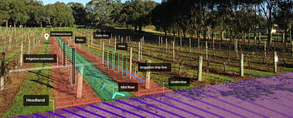
It is with this backdrop that the #Collabriculture project was created and supported by Primary Industries and Regions South Australia (PIRSA), through the SA Wine Industry Development Scheme. The initial objective has been to bring together a broad group of stakeholders across the wine industry as well as mapping experts, to meaningfully describe the key features of vineyards, such as blocks, rows, vines, posts and midrows, in a way that will allow accurate digital maps of vineyards to be created, stored and shared.
Accurate digital maps are the critical building block for turning all the data being collected on vineyards into something that growers can put into practical use. One of the primary objectives of the project is to make digital mapping of vineyards commonplace, standardised, and that these maps adhere to the principles of ‘FAIR’, so that they’re findable, accessible, interoperable and reusable.
#Collabriculture is an open community that’s available to anyone interested in the digital future of the industry. (Please do join the mailing list at collabriculture.com).
During the initial workshops over 100 participants have worked to reach consensus around what they see as the key features of vineyards to have a shared and common understanding around.
These are the insights and descriptions that the #Collabriculture community have come up with, and we would encourage you to take a moment and think about whether we have captured the mapping features of vineyards that are most important to you. Do the descriptions make sense and ring true, and is there anything that’s key that we’ve missed? Please do send any feedback to [email protected].
Vineyard
A vineyard is a property that includes a plantation of grape bearing vines, typically being made up of a collection of individual vineyard blocks.
A vineyard is an agricultural property used for viticulture. Its extent is typically defined by one or more cadastral parcels or land titles. It contains grape vines, usually organised into a number of blocks of vine rows. It also contains other features, such as access tracks, headlands, buildings, and other infrastructure.
The vineyard is the top-level parent of all other features, and the boundary of a vineyard feature is the ‘envelope’ that contains all other objects related to the vineyard.
A vineyard may be the parent of:
- any number of blocks;
- any number of zones;
- any number of midrows;
- an access network comprising tracks, access points, and headlands;
- an irrigation network comprising pumps, submains, dripper lines, filters, field valves, etc.; and buildings and other infrastructure such as environmental sensors, frost fans and hazards, such as overhead power lines.
Block
A block is an area planted with vines, which is managed as the basic operational unit by the grapegrower.
The definition reflects blocks as a primary unit for management in the wine industry, in terms of being centrally referenced for activities such as grape supply contracts, winery intake bookings, and spray record keeping.
A block feature need not be a single contiguous area; it could actually be composed of more than one distinct area.
A block is a theoretical feature: its boundary can’t necessarily be discerned on the ground. It can be defined as a collection of vine row features and its boundary must contain all of these features.
Typically, a block will contain a single grape variety. Small changes to a block (e.g. the removal or addition of a few vines or a single vine row) may be resolved with minor adjustments to the block’s boundary. More significant changes (e.g. grafting a new variety onto a part of the block, or removing vines and replanting with different varieties) would typically result in the creation of a new block object(s), with a unique identity, and the retirement of the previously existing block. This new ‘descendant’ block may have a large amount of spatial overlap with its ‘ancestor’.
Vine row
A vine row is an arrangement of vines laid out in a linear or curvilinear pattern, with defined row ends, such that they can be accessed by the headlands and midrows.
A vine row is a curvilinear feature, and with the exception of bush vines, it is typically made of posts and wires (the ‘trellis’), as well as vines. It has a canopy, which is the ephemeral extent of the leafy cover of the vines during the growing season.
A vine row is typically identified by a row number, with numbering incrementing to traverse the block.
Other features of a vine row:
- a child of, and contained by, exactly one block;
- disjointed from (doesn’t intersect) other vine rows or mid rows; and
- a parent of any number of vines, typically evenly spaced along its length.
Vine
A vine is a single grape bearing plant, grown along a vine row with regular spacing between trunks, and an above-ground structure (trunk, cordon, canes) which is typically trained along a trellis.
Not all viticulture data managers will choose to manage their vineyard data at the vine level; for some, the vine row or block level provides a sufficient level of detail. Those capturing individual vines would typically use point features to identify their locations.
The point location of a vine could be referenced in different ways:
- geographic coordinates (e.g. latitude/longitude or another coordinate system);
- linear referencing – the position of the vine in relation to its distance along the vine row (e.g. 42m from the start of the row), or its relative position in the sequence of vines (e.g. vine #20).
Zone
A zone is an area within a vineyard that is the subject of a specific activity.
Examples include:
- an area that is irrigated on a schedule, with a fixed watering infrastructure;
- an area planted with a specific variety in one planting event; and
- an area requiring specific management practices.
This is a flexible concept and allows for any activity with a spatial extent to be captured in space and time.
It may also be associated with specific site features (soil gradient, texture, depth, etc.), inducing significantly differentiated impact, relative to other areas within the block, on vine performance such that differential management is required or is chosen to be applied.
A zone may be associated with specific management intentions for grade, yield, style or other outcome (cost reduction, etc.), a single event (or instance of an activity), or could be associated with repeated or ongoing activities.
What’s next?
The #Collabriculture project exists so that the Australian viticulture community can start moving together towards the opportunities that advancements in digital technologies are creating. This is not something that can be built by outsiders, not if it is going to work for our industry on our terms. It will continue to need community involvement from the ground up in order to implement technologies that make sense for the work that we do now and the work we want to be doing in the future.
To join the community pushing accurate digital mapping forwards for the wine industry, please go to collabriculture.com.
Reference
Oli Madgett has a family vineyard in the McLaren Vale wine region and is the co-founder of AgTech start-up Platfarm. Additionally, Oli runs Adelaide AgTech meet-ups, is a member of the AgriFutures Ignite Panel and the AgTech advisory board for PIRSA. He is also an AgTech mentor and has used his vineyard for tech trials, including with the University of Adelaide and CSIRO.
Lyndsey Jackson is based on the Yorke Peninsula in SA and is Platfarm’s CTO and co-founder. Lyndsey has years of experience in the open source and developer world. She also comes from a community development background, and brings impact awareness and a big picture frame of reference.
John Bryant has been a GIS specialist for 25 years with a particular focus on open source geospatial software and open data, working in many disciplines, including Indigenous mapping, tourism, and mining. He was the founding chair of OSGeo Oceania, and is passionate about working with communities to build a shared vision for a human-centred future.
Andy Clarke is the CEO of GAIA Innovations, GAIA are responsible for the national scan of vineyards for Wine Australia which helps growers understand their vineyards better through insights derived from high-resolution satellite imagery. Andy is a Nuffield Scholar and has 20 years of experience as a viticulturist across South Australia and Victoria in a variety of roles.
This article was originally published in the January 2021 issue of the Australian & New Zealand Grapegrower & Winemaker. To find out more about our monthly magazine, or to subscribe, click here!
Are you a Daily Wine News subscriber? If not, click here to join our mailing list. It’s free!